How far you live from Boston barely tells you what a house costs
Distance is supposed to be the master price knob, but commute time explains just 28% of what a house costs. The median is flat across the whole first hour, and at any given commute prices run nearly threefold — Lawrence and Duxbury are the same 58 minutes from downtown, at $500k and $1.4M. The town decides the price, not the map.
The intuition is so natural it feels like a law: the closer a town is to Boston, the more its houses cost. Distance is the master knob; everything else is detail. Across 223 towns the intuition is true on average — and almost useless in practice. Commute time explains just 28% of what a house costs. The other 72% is something else.
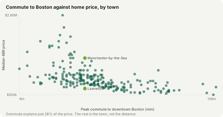
The picture is a cloud, not a line. It drifts down as the commute lengthens — the correlation is -0.53 — but at any vertical slice, the prices are scattered from floor to ceiling. Distance sets a soft ceiling and a soft floor. It does not set the price.
The price is flat for the first hour
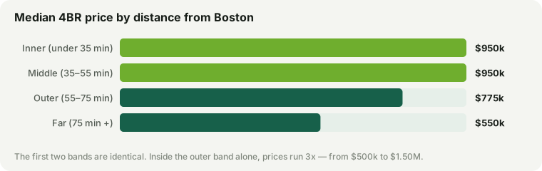
Group the towns into rings and the gradient turns out to be mostly a cliff at the edge, not a slope. The inner ring, under 35 minutes out, has a median 4BR of $950k. The middle ring, 35 to 55 minutes, is $950k — the identical figure. Only past 55 minutes does the median actually drop, to $775k in the outer ring and $550k beyond 75 minutes. Half the map is one price.
Same commute, triple the price
The spread inside each ring is the real story. Take the outer ring alone — towns 55 to 75 minutes from downtown. Prices there run 2.8×, from $500k to $1,400k. Lawrence and Duxbury are the same 58 minutes from Boston. A 4BR house in Lawrence runs about $500k; the same house in Duxbury, $1,400k — nearly three times as much for an identical commute.
So if the drive doesn’t explain the gap, what does? The things this site spends its time measuring. Two towns an hour out can sit a full tier apart on schools; one can be on the water and the other landlocked; one can have a walkable center and the other a highway exit. Those differences move price far more than twenty minutes of commute — which is exactly why the character of a town is where the money is decided.
What this is and isn’t
The prices here are our modelled 4BR estimates and the commute is a modelled peak door-to-door time, so read the shape, not the decimals: a weak gradient and a threefold spread survive any reasonable error in either. And “weak predictor” is not “no predictor” — the far ring really is cheaper, and if your budget is fixed, driving further genuinely buys more house. The point is only that distance is the beginning of the question, not the answer: picking a commute band still leaves you a threefold range, and which end you land on is a choice about the town, not the map.
4BR prices and peak Boston commute times are this site’s estimates, shown on every town page. Site data updated September 17, 2026. Prices are market estimates, not appraisals.